Queen Mountain – near Bonners Ferry, Idaho 08/15/2020

COVID-19 Perspective:  We had the trail completely to ourselves!  As we were pulling away from trailhead two cars showed up but the trail was fairly wide in most places to allow for social distancing, with only a few places where it was too narrow to provide distancing.

The Trail:

  • Length:  4.6 miles
  • Moving Time:  02:13:22
  • Elevation Gain: 817 feet
  • Difficulty Rating:  Easy
  • Trail Surface:  Packed dirt and some rock
  • Areas of Caution:  At the top there were some steeper areas where we would not let the kids roam too far but for the most part the peak was flat with lots of room to move around.
  • Running Wild:  The only thing that stopped us from letting them run too wild and free was the evidence of large animals.  One couple that pulled into the trailhead as we were leaving carried a firearm and I suspect this is for good reason.

What’s in it for the Kids:  Lots of space to roam around up top for exploring and prime picnicking. 

What’s in it for the Adults:  The hike was nice and easy, with pretty awesome views from the top.  The ease of the hike was a plus, as the kids were able to tackle it no problem.

Overall Rating:  7/10 – I prefer more of a challenge from a hike, which is why this one is rated a little lower but you cannot go wrong getting to the top of any mountain.

We had a slower start this morning and hit the road by 6:30 am.  We had planned a longer hike but were not feeling overly motivated and decided to go for a shorter and easier hike.  Biff and I purchased new hiking shoes the previous day because his just were not comfortable for him and mine had deteriorated enough overtime that I had gotten some pretty hideous blisters over the past two days.  We were both pretty excited to try out our new shoes!  On our drive to the trailhead we saw a Mountain Lion run across the road – it was incredibly awesome!!

The first portion of the trail was mostly flat and straight through the forest.  After a quick ascent we reached Queen Lake.  This was a small lake in the middle of the forest, which looked so peaceful and secluded that I really wished we could have camped there. 

From there it was a rather steady climb to the top.  The trail itself transitioned from hard packed dirt to more dust/sand with rocks (big and small) scattered throughout.  We even saw a huge pile of bear poop!  From there on out we made sure to make tons of noise singing songs from the Sound of Music and telling silly fart and poop jokes.

Our first “peak” was not actually the top but a nice ridgeline with awesome views.  From there we could see another higher portion of the mountain and made our way there.

The peak was awesome!  We found two geological markers!!!  Blaze is quite fond of geological markers and when Biff found the second one, he was so proud to be able to show his daddy his AMAZING find!  We also found the remains of an old wood structure with broken glass, bullet casings, screws, wood planks, etc.  The peak was flat and allowed for exploring, which we took full advantage of and stayed exploring and snacking for 45 minutes, give or take. 

Three days prior, someone from California placed a can with a jar, notebook, and pencil as a peak register.  We were only the second group to sign!

On our way back down the mountain we sang Christmas songs with our own versions, including poop and fart talk, picking on one another the entire time.  Dad is VERY talented!  We saw one couple pull into the trailhead as we were leaving and several other cars heading up the mountain as we travelled down.  Looks like we were there at the right time and had the place to ourselves!

Thank you for joining us on our little adventure!  Hiking does wonders for our soul, contact with nature in general does and at this point in our journey I could finally feel the stress melting away.  It almost seemed like the pandemic was no longer a part of our lives – if only we could bottle that feeling up and take it with us everywhere.  As always, take care, stay safe and HAPPY HIKING!!

Scotchman Peak – Clark Fork, Idaho 08/13/2020

COVID-19 Perspective:  Early in the morning we only saw a few people on the trail but it was quite crowded by the time we made it down.  There was enough space on the trail to allow for social distancing and everyone we met on the trail was polite and gave us space, as we gave them space. 

The Trail:

  • Length:  7.3 miles
  • Moving Time:  04:14:49
  • Elevation Gain:  3,317 ft
  • Difficulty Rating:  Moderate
  • Trail Surface:  Packed dirt to the top and tons of scree at the peak
  • Areas of Caution:  We felt pretty comfortable with the kids on this one.  Just be cautious on the scree and of the Mountain Goats (yep Mountain Goats!)
  • Running Wild:  We certainly did let them run wild and free on the way up and more so on the way down.  But we definitely exercised hand holding at the top, just in case.

What’s in it for the Kids:  Did I mention the Mountain Goats?!

What’s in it for the Adults:  The views were amazing almost immediately and just kept getting better as we continued on.  The Mountain Goats were a real treat and definitely a favorite part of the hike for all of us.

Overall Rating:  9/10 because of the amount of people towards the end – we really like hiking on our own away from the crowds.  If we had gotten there an hour or two earlier, this would have been a 10/10 hands down.  Perfect start to our 2020 summer adventure!

We were up at 5am and were greeted by an amazing sunrise off our bedroom, open porch.  What a way to start the day! 

We were on the road to Scotchman’s Peak by 6am.  Combo had chosen this trail because the description said people saw many Mountain Goats and it was all she could talk about.  The road in was bumpy and we missed the initial turnoff, driving nearly a mile before we noticed.  Note:  do not use the driving directions provided by All Trails.  There are a few reviews which give you far better directions and will save you a TON of time.  We ended up using our GPS map to navigate to the trailhead and boy oh boy was the road bumpy!!  When we reached the trailhead there were two cards there, one of which had a person sleeping in it.

We hit the trail and were met with switchback after switchback and a steady incline.  Some portions were steeper than others but it was definitely a steady rise to the top.  About halfway up, the thick tree coverage started to lighten up as we discussed the various animals and crops, we would have if we won the lottery and started a ranch in Montana.  At this point we encountered three gentlemen, one with a shotgun (which the kids questioned) whom had camped on the mountain the previous night.  The kids were in such an awesome mood and we praised them to the moon and back.  They were delighted when we told them this would be the hardest hike in Idaho.  I might have also told them that the longer the hike, the more we would spoil them.  They actually asked for more miles!!

As we climbed and climbed the view became more and more expansive and spectacular.  We could see the surrounding mountains and gorgeous Lake Pend.  Pictures do not do the beauty justice nor do words.  Amazing!!

In a few places the tree’s stopped and we hiked through mountain grass and portions of scree, this was where the views were the best!  And the scree is where Combo heard and saw Picas!  Combo squealed with delight, which made our hearts soar.  The kids were thrilled by this time and had an extra pep in their step.

The top of the mountain was covered with scree and a little difficult to navigate but manageable.  Nearby we saw snow but were unable to reach it as it was on the side of a cliff.  The kids had just about given up hope of seeing a Mountain Goat when we reached the false summit and BAM there were 3 standing right on the trail we needed to take!  We stood around taking pictures and making lots of noise, hoping the Goats would move on but no luck, they started to approach us!  Signs were posted which asked people to maintain at least 100 feet from the goats, so we retreated.  The goats followed us for some time but when we noticed they had stopped, we stopped for lunch.  We found a large rock and sat down to enjoy our late morning treats.  This was cut short because the goats found us again!  We packed up and headed back down.

We saw at least 30 people on the way down and Biff warned each and every one of them of the goats, like he was an expert.  It was pretty cute.  As the number of people grew, our pace quickened to the point were running often, kicking up copious amount of dust and we were completely covered by the end! 

Back at the car we were so proud of the kids and they happily chittered away about this was their favorite hike yet!  And even cooler, we actually saw a Minnesota license plate!  Boom!  Blaze and I wholeheartedly agreed.  We drove through the host town of Clark Fork, which was really quaint and somewhere we could see ourselves visiting on another trip out West.  One odd thing we did see was a car that was riddled with bullet holes and broken out windows.  Odd.

That was it for this one folks.  If you are ever in the panhandle of Idaho, this is a definite must see!  We have hiked many trails and I would put this one in my top 20, for sure!  I’ve been slow to write about our summer adventures in light of everything that is happening in our world around us today.  It has taken a toll on us all.  I feel compelled to say this.  Please take care of those around you, love with compassion, accept the differences of others and celebrate those differences, treasure every human life, be kind, bring joy and not hate.  If we are to overcome all that is happening, we need to unite and be in this together and I mean truly together.  We owe it to one another.  We owe it to future generations.  We need to do better and it starts with each and every one of us.  We need to stop fighting and strive to understand the beliefs and opinions of others.  We need to do better.  And if we stick together, we can do better and we can create a world full of love, compassion, and acceptance.  Take it for what it is worth but please, do what you can to make the world a better place, one act of kindness at a time.  Take care and HAPPY HIKING!!

Nez Perce Peak – Approximately 34.5 miles from Darby, Montana 08/15/2019

Kid Perspective:

  • Running Wild – Despite getting to a summit, we were not concerned in the least with letting the kids loose. We were on a peak but as long as they did not venture to edge there really was not anything to worry about.
  • The Trail – Awesome! We wound along the sides of mountains and ridgelines throughout the entire journey.
  • Trail Conditions – Well..there were downed trees everywhere in the forested sections and when I saw everywhere, I mean everywhere!
  • Bugs and Pests – Bee’s and flies at the summit but nothing else.
  • Plants – Lush greenery!
  • Bathrooms – Outhouse at the trailhead, otherwise practice Leave No Trace.
  • Cell Service – Nada, download any maps or information that you will need prior to heading out.

Trail Information:

  • Length – 11.5 miles
  • Elevation Gain – 1,750 feet
  • Difficulty – Moderate due to the length

Highlights:

  • Combo – Seeing the remains of the old watchtower and the views at the end
  • Biff – Oh Daddy Tree, Oh Daddy Tree (read on for more information)
  • Blaze – The constant scenery and being able to see for miles and miles. The solitude, with the only people around flying high above us in planes.
  • Ripper – Lunch atop the mountain was awesome! And all of the views and changing scenery throughout the hike was a real treat.

Finally the day we had been so looking forward to had arrived – we would be tackling our longest hike as a family yet! We were up at 6:00 am and on the road before 7:00 am, with Nez Perce Peak as our destination. We stopped at the Ranch where “Yellowstone” is filmed on the way out. This was especially cool because this is one of our favorite shows and it constantly reminds us of all of our Montana adventures.

We reached the parking area and trailhead by 8:00 am. The neat part about the parking area at Nez Perce/Castle Rock is that there is a helicopter pad in the middle of it!

Another fun fact (one which we did not realize until much later in the day) is that we actually hiked the other trail that can be accessed by this parking area (Castle Rock) two years ago to the day! After bathroom breaks we hit the trail with our eyes peeled for the Salish Indian grave sites that our book described.

There was an initial steep incline to the trail but by promising that this would be the hardest part, the kids endured it without too much complaining.

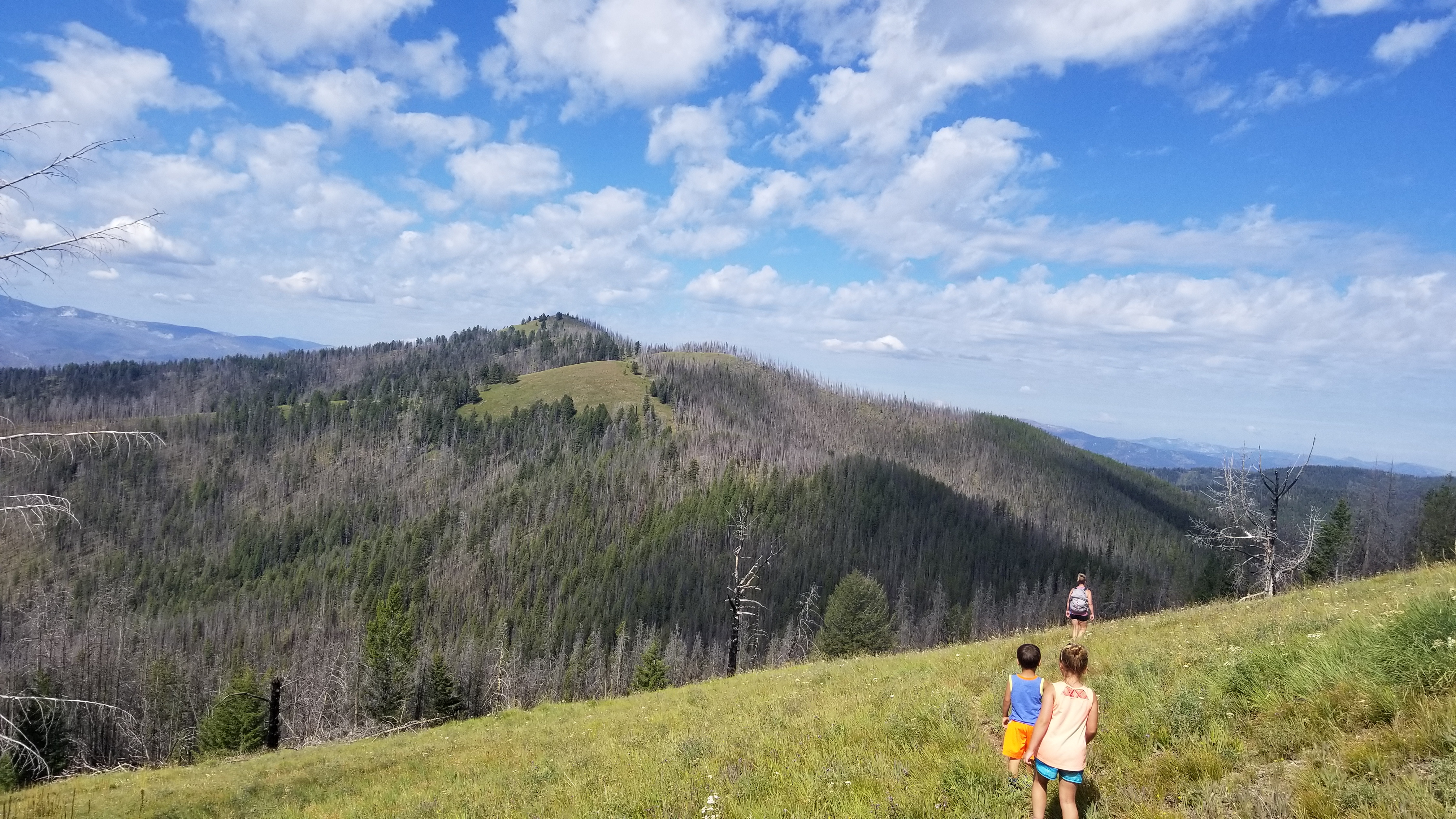
The trail took us along our first ridgeline, treating us to spectacular views of the surrounding mountains. We continued to keep our eyes peeled for the grave sites but were unable to locate them.

As we left the trees we marveled at just how completely surrounded we were by the mountains and wilderness. Our souls were at peace and we talked about how the trail was created by the Nez Perce and Salish peoples who traversed the trails many years ago. The kids wondered what it would be like to always travel on foot, especially over and through so many mountains.

My all time favorite movie is “The Sound of Music” and I really felt like we were in the middle of the story line as we continued our journey. I may or may not have broke out into “the hills are alive with the sound of music” at this point – not sure the kids appreciated it too much but they pretended like it was a big deal. And if you looked closely you could see the road that we had traveled the day before – so tiny!

Re-entering the second forested ridgeline we came upon our first (of many) downed trees. Initially this was a fun challenge for the kids but by the end they were done with them.

The forested ridgeline and tree challenge did not last forever and eventually we came to another trek along the mountainside. It was absolutely breathtaking and I could not imagine any better place to be on earth. This trail quickly became my favorite trail to date.

Out of nowhere we heard a loud noise directly to the right of us off the trail, followed by a grouse taking flight. The solitude of the trail thus far had lulled us into a calm and tranquil state which the grouse easily disturbed, lending us to shouting and jumping in surprise. My heart was racing! As we looked for where the grouse went, we disturbed four more grouse, which made us jump again. The funny thing was that the grouse took off from their hiding places but never went far from us – we did not seem to bother them.

Making our way back into the forest we encountered more downed trees. Climbing over trees and happily snacking, we made a deal with the kids that we would stop for breaks every mile, which seemed to please them. We brought many different snacks with and kept switching the treats up.

Branching away from the Divide Trail and onto the Nez Perce trail we encountered even more downed trees.

In the forested section we found woodpeckers that were certainly not afraid of us, large animal prints (we were not along but never saw any of them), and a burned area.

Castle Rock continued to move farther into the distance as we entered another prairie section where we walked the ridgeline.

Dad pointed out a peak and declared that was our final destination. We did not believe him because it looked so incredibly far away…we had yet to learn our lesson…Dad was once again right (grr).

Back into another forested area, we climbed over and under trees, and around them when too difficult for anything else. We were getting our exercise that is for sure!

Eventually we could see the summit!! Everyone became excited with a surge of energy rushing through us. Gummy Bear after Gummy Bear, we approached the top, only to realize we had stumbled upon a false summit. This dashed all of Biff’s dreams, requiring lots of encouragement and treats to keep moving.

Climbing through burnt trees, downed trees, and lush green undergrowth we found several large animal poops and prints. We wondered where they all came from? We also found some really cool rocks!

Biff hung behind, needing many Gummy Bears to continue while Dad and Combo dashed on ahead.

When we reached the top we were breathless but not due to exertion. It was absolutely incredible at the top! We were 100% completely surrounded by mountains and rugged wilderness – no roads could be seen nor people. I could have stayed there forever!

Alternating between a leisurely lunch and exploring the remains of the old watchtower, we thoroughly enjoyed ourselves. The kids found old pieces of glass, screws, and pieces of metal. It was really cool!

Soon we were overrun by bee’s and knew we had overstayed our welcome. It was time to head out!

Combo and I decided we would count all of the downed trees on our way back. In order to count, we needed to either a) have to climb over the tree; b) scoot under the tree; or c) go around the tree because it blocked the trail. Let the counting begin!

Again the hills were alive with music and we were all still in pretty good spirits…this would not last.

It started to get quite warm as the sun was out in full force now and we were not always afforded the shade that the forested areas provided. The open ridgelines started to become long and HOT.

As the force of the sun and heat grew, so did the cheering on for the kiddos – we also broke out the big gun treats. You can do it guys!

Entering another forested area, Combo and I made it to our 100th downed tree and had to commemorate the moment. Now mind you, Combo was going to help in this endeavor but because she is only 8 she was often distracted and needed frequent reminders of the tree count – but it was still a momentous occasion for us.

Biff and Dad teamed up at this point, but Biff was really having a rough time – he was DONE! Dad to the rescue, making up a fun new song…”Oh Daddy Tree, Oh Daddy Tree – I’ll decorate your beautiful butt cheeks”! As you can imagine, each family member was rotated into the song, with innumerable body parts decorated. A week later, I still have this song stuck in my head!!

We counted 132 downed trees and have the bruises and abrasions to prove it, from climbing over those buggers. Dad ended up carrying Biff off and on, while Combo rocked it! When we had 1 1/2 miles to go, we started looking for the grave site again. We were just giving up the search when off in the distance we spotted it and dashed ahead. The Salish Indian had died at 80 years of age in 1990. We noticed that others had left quarters on the gravestone and the kids decided to do the same. It was a humbling experience at the grave site.

As we started our last leg of the hike, Dad dashed on ahead to use the facilities. Mom, Combo and Biff continued at kid pace but in great spirits all the way to the car! 7 1/2 hours and 11.5 miles later, we made it!!

Of course we needed to treat ourselves to dinner!

This was a tough journey for us but we persevered and did it! We are so proud of the kids!! Please take a moment to let us know what you think and if there are any adventures that you would like us to check out. Happy hiking!

Selway River Trail & Bad Luck Creek – Approximately 65 miles from Darby, Montana 08/14/2019

Kid Perspective:

  • Running Wild – We were confident in letting the kids take the lead on the trail. No big cliffs or areas of concerns when it came to the trail (read on).
  • The Trail – The Selway River Trail wound along the Selway River with pleasant up’s and downs, snaking into the forest here and there.
  • Trail Conditions – Great! There was the usual roots and rocks covering the trail sporadically but nothing that impeded our journey.
  • Bugs and Pests – Nada…BUT we did encounter a Rattle Snake along the Bad Luck Creek Trail and the Selway River Trail is known for Rattle Snake encounters and so for this reason I would highly recommend that you watch the kids closely!
  • Plants – Interesting plant coverage – we were surprised by some of the different varieties of plants that we saw.
  • Bathrooms – Outhouses at the trailhead but then nothing along the way – as always, practice Leave No Trace.
  • Cell Service – Absolutely nothing. We lost service approximately 20 miles from Darby, so make sure you have a good idea of where you are going and that you have downloaded any information you may need ahead of time.

Trail Information:

  • Length – The Selway River Trail is 49.5 miles but we did not cover the full trail. Our chosen path was about 7 miles of hiking in approximately 4 hours.
  • Elevation Gain – Not much on the Selway River Trail, but there were several ups and downs which made things more exciting. On the Bad Luck Creek trail we encountered a steepish incline at first, followed by some switchbacks which leveled out into a fairly flat trail. We did not track the specific elevation gain that day so I cannot really comment on the exact gain.
  • Difficulty – Easy, nothing too demanding.

Highlights:

  • Combo – Being the one to actually see the Rattle Snake…even if it was scary!
  • Biff – Throwing sticks into the water at the Paradise Landing.
  • Blaze – The cool plants we found.
  • Ripper – Not getting bitten by the Rattle Snake!

We were up at 5:00 am and on the road by 5:30 am, knowing that we had a 3 1/2 hour drive ahead of us (from Corvallis, Montana). The road was super remote, narrow, and winding. We lost cell service an hour into the drive…solitude!

Finding ourselves back in the Magruder Corridor, we were excited to see Castle Rock once again! The sign warning of the potential poor conditions of Nez Perce Pass brought back fond memories of memorable hike to Castle Rock in August of 2017. We reminisced fondly of that trail and decided that we definitely would need to hike it again (hopefully the Summer of 2020).

Finding the trailhead for Bad Luck Mountain was difficult. We went 100 yards past the Ranger Station, as described in our guide book and found what we thought was the trail but this ended up being a deer trail, so we turned around. We asked the Rangers and they pointed us down the road, where we found a trail and headed out.

The trail meandered along the Selway River, climbing and descending gently.

The river and trail were surrounded by mountains on all sides and we were treated to expansive views each time we would get to the top of a hill.

Always on the lookout for cool finds, Combo spotted another set of bones on the side of the trail. We have no idea where these came from, so if you have an idea, she would love to know!

We knew that we were not on the right trail because the trail itself was not matching our map at all but we decided to keep going because it was so gorgeous! Just goes to show that in this section of the world even the wrong trail is the right trail, as long as your mind is open to the idea.

Eventually we came across a sign for Bad Luck Creek, which turned away from the river and we took off. Encountering several steep switchbacks right off the bat, we became excited!

Stopping for snack breaks here and there, we were cooking! On one such break, Dad pointed out a very interesting plant…we stopped to look around and noticed they were EVERYWHERE! I am not going to post a picture of the plant but keep your eyes peeled if you head out that way.

At another point we were walking by a bush, when we heard a sharp rattle. Combo swore up and down that she had seen a Rattle Snake. Let’s just say that we were all a bit more cautious from there on out.

The trail became increasingly more overgrown as we went on. We were walking through spiderwebs and deep underbrush that nearly covered the trail completely. With our recent Rattle Snake encounter fresh in our minds, we were starting to hear rattles coming from everywhere (they were not – some might have been Dad messing with us while others were a figment of our very rich imaginations). Nonetheless, at the next creek crossing we decided we would head back for the day.

Still jittery about potential snakes (it did not help that Biff was now chiming in with the rattle sounds and pretending to yell at a Rattle Snake), we were all trying to figure out exactly which bush the rattle came from, making progress a little slow. We ended up giving each dried bush that touched the trail plenty of space, just in case (Dad did too, even if he will not admit he was a little freaked out).

The Selway River Trail was littered with manure – were constantly walking over droppings of one sort or another. The trail is actually a used stock trail so the manure was to be expected. When we met back up with the Selway River Trail we found fresh horse manure and guessed that the Forest Rangers had taken to the trail behind us, perhaps to make sure we were ok.

Making our way back along the river, we pointed out cool rocks and HUGE pine cones. Combo and I even saw a tiny snake slither across the rocks – it appeared to be a vibrant blue and was super fast!

Biff was starting to become a little testy and Dad tried to cheer him up by squirting water on him…this did not help AT ALL. What followed next was hilarious! Biff began to lecture Dad on the importance of not wasting water on the trail and how irresponsible doing something like squirting water was. Nothing like the pot calling the kettle black!

So Dad suggested that Biff also squirt water on him and guess what? Biff cheered right up! So much for the lecture eh? Biff was able to squirt water on Dad in such a way as to make him look like he had peed his pants…this really made Biff’s day and it was happier hiking from there on out!

We began discussing which toy the kids would pick out after our hike. The previous night we had made a deal with them that if they were able to make it through the hike without any major meltdowns, we would purchase them a toy of their choice. Boy oh boy did they have ideas!!

As the trail wound closer to the river and became flatter, the kids were renewed with energy, as they knew they had nearly made it and were that much closer to their prizes! Of course seeing the Paradise Landing bridge sealed the deal and they were off!

Kids LOVE the water so of course we had to walk down the boat ramp and soak our feet in the water, while watching Forest Service workers perform maintenance at the boat launch. And we certainly could not miss the chance to throw a couple sticks into the water!

Our drive home was a bit more scary, as we encountered three large Forest Service trucks hauling dirt to even out the road. Each time we encountered a truck it was just around a corner on that tiny dirt road, forcing Dad to stop quickly and back up several hundred feet to the next pull off. We were certainly happy when the road opened up again! All in all, wrong trail and everything, it was another wonderful day that were so thankful to have been able to enjoy!

Thank you for taking the time to read about our adventures and I hope you were able to find inspiration to get outside and enjoy that great big world of ours! Until next time, take care!

Skookum Butte Lookout – Near Lolo, Montana 08/10/2019

Kid Perspective:

  • Running Wild – Feel free to let the run their little hearts out until you get to the lookout. Once at the lookout, there are steep cliffs and caution is definitely needed.
  • The Trail – We moved through a previously burned area that was mostly flat with gentle ups and downs. Once we moved into the area that was not burned we encountered a steep upward climb all the way to the lookout.
  • Trail Conditions – Mostly single track, packed dirt.
  • Bugs and Pests – Bees among the wildflowers but they did not bother us.
  • Plants – So many wildflowers – it was pretty crazy how they took over the area of the trail that was burned in 2017!
  • Bathrooms – Nada…please practice Leave No Trace.
  • Cell Service – None. Download the trail information before you start the drive to the trail (we lost service early on our drive – T-Mobile).

Trail Information:

  • Length – 2.2 miles
  • Elevation Gain – 1,030 feet
  • Difficulty – Moderate but a strenuous incline closer to the top.

Highlights:

  • Combo – The views at the top!
  • Biff – The fair is next when we are done!
  • Blaze – Seeing the old Fire Tower which was in the process of being restored.
  • Ripper – Meeting friendly hikers along the way and learning more about the area from them.

The road to the trailhead was 12 miles of bumpy gravel. Along the way, we saw several pickup trucks and groups of people either collecting Huckleberries or firewood. We drove through the area that was burned in the 2017 Lolo Peak fire.

The trail started in the burned area and slowly made it’s way along the Montana/Idaho border. The regrowth was impressive and there were many wildflowers covering the wounds left behind by the fire.

As we continued to marvel at the regrowth and the odd path that the fire took, we eventually found ourselves in a lush forest with expansive views of the mountains surrounding us on all sides.

Seeing the burn of the fire was incredible.

We continued on, gently climbing and enjoying the views.

We even saw a downed tree that encapsulated a rock! Combo tried to move the rock to no avail:)

Biff found a stick that was perfect for a walking stick and decided that he MUST take it with him (we convinced him that he should discard the walking stick later because he could jet on ahead much faster without it).

Slowly the trail began to climb and climb, until we felt as if we were going straight up. Game on! It was a little strenous and got our blood pumping for sure!

The kids were doing so great that we actually caught up to a couple pf hikers.

They decided to hike with us. Perry chatted about the area and the lookout at the top. We listened to Perry chatter on as we made our way to the top.

The last leg was a scramble across and up large boulders – very fun!

We stayed at the top, taking pictures and snacking on Combos and Salted Nut Rolls for about 15 minutes, while Perry continued to talk our ears off. He was really a great guy.

We said goodbye to Perry and Sandra and headed back down, sad to leave fellow hikers that felt the same way about the area that we did.

We were glad that we left the tower when we did because the clouds rolled in and it started to rain…I mean seriously rain! Speed up guys! The drops were big, fat and cold!

This gave the kids motivation to kick into gear and they did great!

We made it down in record time…just as the rain stopped. I hope Perry and Sandra made it out ok!

The road down was just as windy and awesome as the way up.

The entire day we had been promising the kids that if they did a good job hiking we would go to the Western Montana Fair in Missoula, Montana and we did just that!